Olive Mount and Wavertree Ridge.As I posted in the last blog, you can find out more about the 7 Walks and download maps and/or the Points of Interest Guide at http://www.bikeright.co.uk/merseyside/7hills/
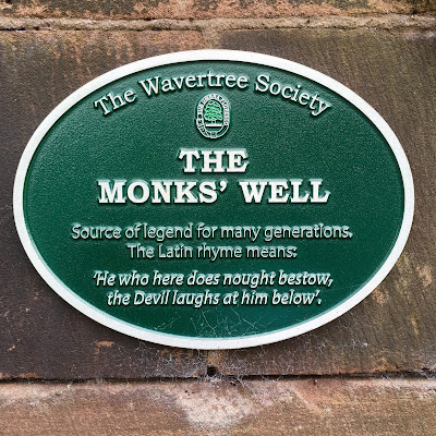
Because it was a Sunday, we decided to drive to the start of the walk, and parked just beyond The Medieval Monks’ Well...
...which it is believed, at one time, to have served a local Cistercian monastery on Olive Mount.
The Monk’s Well has Latin text, which reads:
‘QUI NON DAT QUIOD HABET DOEMON INFRA RIDET. ANNO 1414’This freely translates as,
‘He who here does nought bestow, the Devil laughs at him below’The Cross was replaced in the late 19th century and inscribed,
according to tradition,
‘DEUS DEDIT, HOMO BEBIT’This translates as,
‘God gives, man drinks’From here we headed past the children's playground (which was once the village lake) to the Village Green upon which stands the Sheriff's Lock-up...
...(Not Everton's one this time).
During the late 17th and early 18th centuries tourists began to come to Wavertree from the town of Liverpool, to swim in the village lake, picnic on the green, and drink in the numerous taverns.
As many of these were getting drunk and making a nuisance of themselves, in 1796, the Lock-Up was built to accommodate them!
The Lock-Up has also be used...
- as a temporary mortuary for victims of a local cholera epidemic in 1832 and,
- it housed refugees from the Irish Potato Famine, during 1845 and 1846, who had no other form of shelter.
By 1852, the building had passed its useful life and was subsequently ‘beautified’, by James Picton in 1869, with a pointed roof and a weather-vane.
It is still one of the the many attractive features on our Meander.
NOTE:The small triangle of land that the Lock-Up stands on, is the only surviving piece of common land in the City, so, if you have any livestock that you wish to graze, this is the place to do it!Next we headed into the middle of the roundabout to see the the former waiting room for the tram service that used to run through Wavertree Village and, standing next to this, the tall, impressive, late-Victorian clock-tower...
...generally referred to as the Picton Clock.
 |
| View down High Street |
 |
| One of a number of quotes |
 |
| View from High Street |
The clock was named after Sir James Allanson Picton (1832-1889), who was a resident of Wavertree.
Picton designed many buildings in and around Liverpool, including parts of the Central Library on William Brown Street (the Picton Reading Room is also named after him).
We then left the roundabout and after a short meander down the High Street took an alleyway to the right and then first right, into Arnold Grove to view Number 12...
...George Harrison's Birthplace - 25th February 1943.
I wonder how the people in Arnold Grove feel about the number of tourists that wander into their road?Heading back to the High Street we turned right and, at the right-hand end of the Cock and Bottle pub we saw...
...the small front door and tiny windows of what was once the Smallest House in Britain.
It was built, in 1850, to fill in the side passage alongside the inn. When finished, the house was 6 feet wide and 14 feetfrom front to back.
Back up towards the Picton Clock we turned right along Church Road North, past the Coffee House Pub to the iron gates outside The Royal School for the Blind, built in 1898.
See the Points of Interest Guide for an interesting story about the slave and salt merchant, John Blackburne, who was Mayor of Liverpool in 1788 and lived in the hall that was on this site.
A bit further on we were invited in to the Church of the Holy Trinity (http://www.holytrinitywavertree.org.uk/).
Invited in by the Reverend Canon Janet Eastwood, who saw us, well me, taking pictures of the church.
A very interesting history and interior...
...as well as the War Memorial, which...
...in 1920, was erected and consecrated in remembrance of those who laid down their lives in the 1914-1918 conflict.
Before heading back to the car, we took a left, opposite the Bluecoat School...
It's difficult to believe that this area was once a very large and deep quarry; filled in, in the early decades of the 20th Century.Known as the Haunted Mill you can find the full story in the Points of Interest download.
Time to leave Wavertree Village
To finish our meanders we headed off, in the car, to take a look at Wavertree Botanic Gardens (http://liverpool.gov.uk/leisure-parks-and-events/parks-and-greenspaces/wavertree-botanic-gardens/)...
...a lovely 19th century public park with a walled botanic garden and a Grade II listed curator's lodge.
If the first two walks, of the 7 Liverpool Hills, are anything to go by, we look forward to the next 5.
BRING IT ON!Watch the slideshow of the photographs I took at https://sharalike.com/s/nYCq


No comments:
Post a Comment