Sunday, April 20, 2008

National Wildflower Centre

Chris had spotted the National Wildflower Centre in the Friday Paper; so it was decided to look for a walk nearby. Nothing available we decided to use the large A-Z map of the area and to work out a walk of our own!
Was that the first mistake, I can hear you ask! No it wasn't! our walk took us from the National Wildflower Centre, resisting the call to call there first, through the Victorian Court Hey Park, along the Liverpool Loop Line, through Childwall and Black Wood, into Calderstones Park, along the edge of Allerton Park Golf Course, through Reynolds Park (including a visit to what Chris thought was the best walled garden she had seen), back onto the Liverpool Loop Line and finally returning to the National Wildflower Centre at Court Hey Park. If you were worn out by that then imagine how we felt having completed the 8.45 miles (You can see where we went by going to http://www.gmap-pedometer.com/?r=1816966.
Last year was the 10th birthday of the centre (Plans were drawn up in 1997) but it wasn't opened to the public until 2001. Set in the 35 acre Victorian Court Hey Park, they provide information and raise awareness about the importance of wild flowers to our environment and encourage people to learn about the creation and management of new wild flower habitats - creative conservation. I particularly liked the wild flower bed made up from recycled CDs. Chris had a go on the Traverse Wall (no comments) and I had a play on the large wooden xylophone. (Abide with me!)
Some of the sights in the National Wildflower Centre
There were a number of sculptures made from scrap metal...
A rusting metal flower
...that were rusting among the flowers.
A more colourful fish was in the water near the entrance...
Something Fishy
If I get time I may add him/her to the moblog!
An interesting walk with lots of contrasts and how nice to see parks returning to their former glory!
Blogged with the Flock Browser

Sunday, April 13, 2008

New Brighton - North Wirral Coast

Founded in 1830, Liverpool builder, James Atherton realised that steam-ferries now made this part of the Wirral accessible. He planned a seaside resort like those on the south-coast, including of course, Brighton.
Blackpool 'eat your heart out', among many attractions, most of which are long gone, New Brighton had one of the world's biggest open-air swimming-pools, a pier, a vast pleasure garden with fairground, monkey house, a ballroom and a tower taller than Blackpool's.
Starting our walk at the Welsh end of King's Parade, our eyes were drawn to Liverpool Bay and the wind-farm comprising 25 turbines...
25 Turbines in Liverpool Bay
King's Parade was built in the 1930s from land reclaimed from the sea using material excavated from the Mersey Tunnel. The old sea walls and coastline are visible on the right of the road.
Views across the mouth of the River Mersey enabled us to identify the Freeport at Seaforth...
Seaforth Freeport
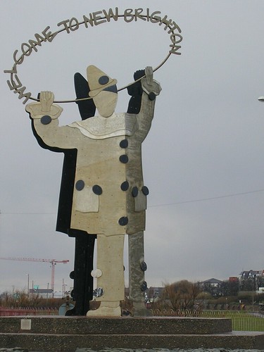
We were greeted by the Aluminium Clown Statue as we entered New Brighton.
Aluminium Clown Statue
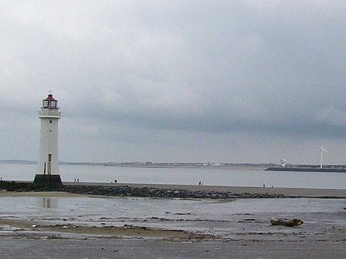
As we walked closer to the River, Perch Rock Lighthouse and Fort, were passed on our left. The lighthouse, because of radar, became redundant in 1973. Built on Black Rock, the most feared hazard on the inward trip to Liverpool, in 1830; it replaced a wooden construction with a light on it.
The lighthouse has often been hit by ships it was there to protect and guide. 90 feet tall it could be seen 15 miles away...
Now privately owned and let for holidays.
The Fort, Perch Rock Fort, is very close to the lighthouse and marks the River Mersey. Planned as part of England's defences against an invasion by Napoleon it wasn't completed until 1826 by which time Napoleon was already dead. It was altered in 1890 and its claim to 'fame' (I'm not sure if that is an appropriate word) is that the guns were only fired twice and then only as warnings; once at the start of WW1 and again at the start of WW2. It was also camouflaged as a tea room in WW2 with the top painted green to look like a lawn from above; 'Tea' was painted on the roof...
3 Flags Union Jack, Stars & Stripes and St George' flag
Turning through 90 degrees we walked along the promenade with views of Liverpool's famous waterfront...
Liverpools Skyline...

Leaving the River we walked through Vale Park with flowers in full bloom...
Gardens in full-bloom
Walking through the streets of New Brighton, past the railway station, we returned to King's Parade and down onto the beach before returning to the car.
About 4.5 miles, the walk had many interesting features and research enhances the experience. If I get time I'll add a map so that you can, if you want to, trace our steps.

Blogged with the Flock Browser

Sunday, April 06, 2008

Video Clips from Wigan Walk

Click to play WiganPier
Create your own postcard - Powered by Smilebox
Make a postcard - it's easy!
Blogged with the Flock Browser

The Paths to Wigan Pier

We started todays 6.1618 mile walk, map available at http://www.gmap-pedometer.com/?r=1763798, in the car park behind Trencherfield Mill, Wigan Pier.
Trencherfield Mill
The floor of the piazza has brick paving that suggests a large rug and giant dominoes. You can make out the carpet element in the picture above.
On the wall, part of Wigan's Public Art Trail, are
Andy Hazell's Three Heads. Installed in 1999, they were part of an exciting mechanical sculpture (automata). The Three heads sat on the wall above a giant mantle piece which featured symbols of the Twentieth Century and a clock. We could only see the heads - the middle one providing an ideal nesting place for a rock dove!
Andy Hazell's Three Heads
Wigan, in general, is closed on a Sunday so the initial walk through the urban environment wasn't as bad as it could have been. The lack of people allows you to see the part-pedestrianised streets at its best. We were confused by the instruction "Just before a dual carriageway go right down setts to St George's Church"; it was the word 'setts' that confused both Chris and I. If you are confused as well it is an old term for cobbles or Cobble Stones! Of course it is!
The River Douglas was joined near where the old Wigan Rugby League Stadium used to be (a Tesco now) Ben and Mandy may remember watching Orrell playing there some years ago.
Past an old quarry called Devil's Canyon, (That's 2 weeks we have seen property of the Devil!), now an adventure playground, we climbed up past former almshouses know as The Receptacle.
Many of the bridges on our route had cast-iron parapets. Apparently Lord Crawford of Haigh Hall made his fortune from iron and seems to have liked to use it ornamentally on the estate.
The last parts of our walk took us briefly onto the canal towpath near Haigh Hall Golf Course and then back through woodland, along an old railway track and the down the Wigan flight of locks from Rabbit Rocks back to Wigan Pier.
It is interesting that Trencherfield Mill Engine is reputedly the world's largest, original working, mill steam engine, the four-cylinder 2,500 hp giant was built and installed in its specially designed engine house at Trencherfield Mill in 1907.  It’s 70 tonne flywheel enabled power to be sent throughout the vast Mill on all five floors, powering thousands of cotton spinning machines.
A very enjoyable walk and perhaps one we will revisit soon, when the bluebells are out!
Blogged with the Flock Browser

Ogden Clough and Swineshaw

Our walk started from a peaceful lane, between arable land and moorland, taking us through the edge of Hollingworth to a nature reserve created around abandoned reservoirs.
The lambs, at Landslow Green, were an excellent start to the day...
April Lambs
and...
More of the same...
To say the walk was muddy was an understatement; in parts it was very heavy under foot. Apparently this walk was "an easy introduction to moorland" - Rubbish! What with boggy paths through Swallows Wood Nature Reserve and steep climbs, in particular after Devil's Bridge...
Devil's Bridge
the walk was quite demanding; it was also, on the plus side, a very 'engaging' walk
As said already Swallows Wood Nature Reserve is based around former reservoirs created by damming Ogden Brook in the 1850s. Concessionary paths thread the woodlands and we were taunted by the 'mocking laugh' of a green woodpecker which, try as we might, we couldn't locate. Higher up, on moorland tracks and roads, we could see Arnfield, Higher and Lower Swineshaw Reservoirs. There were fine views of Manchester over Lower Swineshaw Reservoir. The reservoirs were very blue which made the cold wind feel even colder. We did expect to see some wildfowl on the reservoirs but were out of luck (Not even a cormorant).Passing back through Hollingworth Hall, we returned to Hobson Moor Road having completed 5.7619 miles. The map of this walk can be found at http://www.gmap-pedometer.com/?r=1763741.
The picture below has more details of the Nature reserve...
Ogden Clough and Swineshaw walk
Blogged with the Flock Browser