Sunday, September 14, 2008

The Bridgewater and Norton Priory

The URL for todays route is: http://www.gmap-pedometer.com/?r=2261444 - 5.6 miles in total.
Same guide Riverside Rambles along the Mersey by Ron Freethy; difference is, this time I used http://wheresthepath.googlepages.com/exploreabiggermap.htm, a must for walkers, to map out the walk before we left home.
Whatever you do, if you buy this book, don't depend on either the text or the map; from what I've experienced so far either one or the other is correct but not at the same time!
This time the map is wrong on the return leg; you need to leave the towpath at Norton Town Bridge not Norton Bridge! Be warned.
Armed with map and guide we set off from the opposite side of the canal to a boatyard; it wasn't Preston Brook Marina, as stated in the guide, but was the correct place to start on the map and in the text. Just totally the wrong name!
We made our way towards Norton Priory along the Runcorn arm of the Bridgewater canal.
The fruit laden hedgerows (apples of various types but mainly crab apples, hawthorn berries, elderberries, etc.) and wildflowers were in abundance including the Purple Loosestrife shown below.
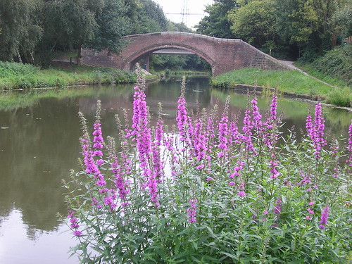
Purple Loosestrife
Little did we know, as squirrels, moorhens, ducks, jays, magpies etc. crossed our path, of what lay in store for us as we neared Norton Priory.
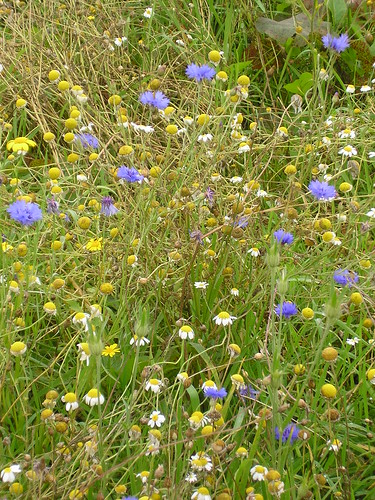
Cornfield Wildflower Meadow
I thought I'd gone back to my childhood; here we had a wildflower meadow reintroducing 'cornfield flowers' such as corncockle, corn marigold, corn chamomile and poppy. When I was a boy.... Mmmm memories. What a pity the flowers were past their best, although the bees didn't think so!
The Priory wasn't open, we were a tad to-early, but the cafe was; tea and cherry scone for Chris and coffee and choc-chip muffin for me.
The Residents were a little shy...

Flowerpot person
The last time we visited was with Ben and Neil when they were both at Summerhill; many changes and perhaps a place to visit when it is too wet to walk.
We retraced our steps leaving the canal at the correct place and heading across fields, under two railway bridges and up onto the Manchester arm of the Bridgewater canal.
There was evidence of early growth of fungi probably due to the very wet summer or should that be 'global warming'?
Early Fungi
Farmers are still trying to gather the harvest and two 'Holland' Combine harvesters were hard at it.
Another enjoyable walk and a note to revisit Norton Priory in the not too distant future.
Blogged with the Flock Browser

The Mersey At Warrington

Our walk last week can be viewed at http://www.gmap-pedometer.com/?r=2261142. 6.6 miles in total. It was the first walk from a book I'd purchased when the car was in for its 80k service; Riverside Rambles along the Mersey by Ron Freethy.
It's a good job the walk was enjoyable because the guide wasn't! I think is was one of the least helpful books I've ever tried to use and the first one that I had difficulty in fathoming where I was, let alone where I had to go.
Enough of moaning - we started at Paddington Bank (which was some way from the A50/A57 Junction it was supposed to be next to) and, once I'd convinced Chris which way was upstream, we headed off towards Manchester. We were soon in open countryside disturbed only by the noise of oars as various crews made there way downstream. I'm not convinced we saw the long disused navigation known as the Woolston Old Cut; it had been important before the opening of the Manchester Ship Canal in 1894.
Water meadows, beside the Mersey, had cattle grazing in what had turned out to be a nice day.
Cattle grazing on the water meadows.
The guide rambles on about the Black Bear Canal which I later discovered was near the end of the walk; God only knows why it was added as the second part of the walk;
You will see from the map that we took a detour and had to retrace our steps; we also missed Grey Mist Pond as there was no indication of when we left the bank of the Mersey. (Remined to myself - plot the walk on the map before leaving home! Grrrrrrrrr!
There was no mention of the canal we walked along and, when we reached Woolston new and old weirs having turned right it wasn't anywhere near where the guide suggested. Any remnants of the gunpowder works seem to have long gone.
Apparently we had to desend to the Manchester Ship Canal, which was several feet above us, and follow the obvious route parallel to the village of Thelwall. I think it is called a towpath! Ron Freethy is, apparently a journalist, his guide has confirmed that you can't believe anything written be a Journalist :-)
Thelwall means a "pool by a plank bridge"
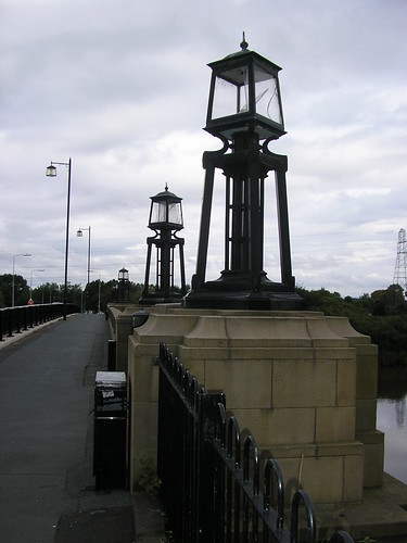
We left the Manchester Ship Canal at Latchford Locks making our way back to the car. We crossed the Mersey once again, on the A50 and I was particularly taken by the lighting on the bridge...
Lighting on A50 Bridge over River Mersey
Now I could see the Black Bear Canal that Ron had gone on about at the beginning of the walk; it comes to all who wait! Apparently it was named after an existing pub (much to the disappointment of Chris).
The final stretch was along the river again, upstream, and alongside some impressive allotments.
In general a very enjoyable walk, in spite of the poor guide used.
Blogged with the Flock Browser