Sunday, October 27, 2013

Where had he gone?

Last time we visited Hale it was with my Sister-in-law and Brother-in-Law.
Partly for the walk and partly because of John Middleton - the giant!
Situated across the road from the church there had been a large Beech tree trunk which, in 1996 was carved with representations of John Middleton, Hale Lighthouse and other local symbols, by sculptor Philip Bews in 1996.

Sadly on our last visit, due to disease and in the interests of public safety the tree trunk had been removed by Halton Borough Council. Chris and I didn't know that when we took her sister and husband for the walk.
Today we discovered that in April 2013, the wooden sculpture has been replaced by a bronze statue 3 m tall by local sculptor, Diane Gorvin.

John Middleton (1578–1623) 

...was an English giant commonly known as the Childe of Hale. Most of what is known about him is based on oral tradition and legends. Legend tells that he slept with his feet out of the window of his small house. Tales also credit him with great strength.
The URL for todays 4.1726 miles walk is http://www.gmap-pedometer.com/?r=6123444 
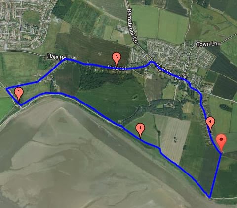
Starting at the parking area at the end of Church Road, we headed off down Lighthouse Road to...

Yes you've guessed, the Lighthouse.
We couldn't decide if the tide was going out or coming in. By the end of the walk it was obviously going out.

Constant calls from curlews accompanied us as we walked along the Mersey. The clockwise direction, chosen by wind direction,was a good move.
Apparently the walk, so far had been part of the Mersey Way
 - "Is there any other!"
Oglet Lane was as litter strewn as ever as we headed in land along Dungeon Lane and right onto Bailey's Lane, past the landing lights for Liverpool John Lennon Airport

Now sheltered from the wind, coats were unzipped as the sun emerged from what had been a cloudy day.
Just before the junction of Church End, Church Road and Within Way stands the new bronze of the Childe of Hale. He is looking towards the cottage where he lived.  

According to contemporary accounts and his epitaph, Middleton grew to the height of "9 feet, 3 inches" (2.81 m).
Because of his size, landlord and sheriff of Lancashire Gilbert Ireland hired him as a bodyguard.
An impressive bronze but I didn't feel it was as captivating as the Beech trunk carving.
If you visit Liverpool, or live locally, this is a walk worth doing. Bird watchers in particular will, as we did, enjoy the experience.

Sunday, October 13, 2013

Bickerstaffe Loop

A quick look on my new Ordnance Survey Explorer, plastic coated, Active Map and we were off on our Sunday 5.3889 miles walk.

No I didn't know the distance until I plotted the route, which can be viewed at http://www.gmap-pedometer.com/?r=6110784

Why this route? Well there were a couple of woodland that I've passed many times on my journeys up and down the M58 that I often thought, "We'll do a walk one Sunday to take a closer look at those woods". Today was that day.

The other reason,it was close to home and there was an off chance of rain! 

Approaching from Church Road to Bickerstaffe, we parked at the church.

Heading back along Church Road, we turned right along the edge of,then through, Intake Wood


Crossing fields,using very clear well kept paths we skirted Jubilee Wood and then across the A570.

It's difficult to imagine the now disused mine shafts when mining was active here. The woodland, well established, hiding the slag heap and any signs of mining. This whole area must have been so different.

Lots of signs of Autumn with leaves changing colour, that autumnal aroma and fungi.


Some of you may wonder why we meandered as much as we did, before reaching Collery Plantation, next to White Moss Road South. Well let's just say it avoided going through farmyards and the potential of confrontations with farm-dogs. Something one of us isn't comfortable with. 


There was an interesting collection of plants just before entering Collery Plantation.


Will certainly attract a wide range of birds.

A slight detour, to look at the lake in Collery Plantation,

...and we were off again to walk to, what we had avoided so far. Lyelake Farm

Chris wondered if the farm's name was linked with the mining activity in this area. Lye is a term that can refer to the liquid obtained by leaching ashes (containing largely potassium carbonate or "potash"), or to a strong alkali which is highly soluble in water producing caustic basic solutions. It is commonly the alternative name of sodium hydroxide (NaOH) or historically potassium hydroxide (KOH). Both sodium hydroxide and potassium hydroxide are used in soap making. Sodium hydroxide is often used to make solid soap while potassium hydroxide is used to make liquid soap. Soaps made of potassium hydroxide are softer and can more easily be dissolved in water than sodium hydroxide soaps.

We had commented about how many fields of potatoes hadn't been harvested. Walking through the farm answered that question. Every barn, trailer and other storage spaces were packed to the brim.

It was also nice to see the Saddle Back pigs. In this field, between Lyelake Plantation and Lyelake Lane, was one boar with seven sows.


Crossing the A570, next to the Stanley Gate Pub, well worth a visit (although on our last visit the food was good but, the choice of Bitter Beers was poor) we made our way past the now converted windmill and through another plantation following Bickerstaffe Brook.

Across The M58, via a footbridge, we made our way past Little Wood, onto Hall Lane and back to Bickerstaffe Church.

Another nice walk on the Merseyside, Lancashire borders and yes we avoided the rain!

Sunday, October 06, 2013

Sefton’s Natural Coast

Chris and I have walked the Sefton Coastal path and revisited many sections we like. 

Today it was about walking in the sun along the beach and back through the unique dunes and forest environment.

6.3084 miles in total, you can view the route taken at... 

For those of you who haven't walked the coastal path it starts from the northern outskirts of Liverpool and passes through dunes, marshes and the towns of Southport and Crosby. It also passes the Ainsdale Nature and Formby National Trust Reserves.

Sefton’s Natural Coast, as it is now known, is the largest undeveloped dune system in England, extending from Southport and the Ribble Estuary to Seaforth at the mouth of the River Mersey.

Today we started and ended at Formby National Trust Reserve
Making our way from the car park, just past where non-members pay their £5 to park, we headed through pine woodlands towards the beach.

At one of the turns Chris played the wooden chimes...

we both completed a "balance path", looked at a woodpecker carving...

and peered through a "mounted magnifying glass" at some bracken fronds.

Arriving at the beach, after climbing over the dunes...

...we were drawn to the shore.


For once we didn't have our "Who can find the longest razor shell?" competition but, in places, you couldn't avoid them. There must be another use for them.

After 3 miles we cut up through the dunes and on to a number of different coloured path routes; from memory we walked part of the red, blue, black, white, purple, and the Coastal path routes.Through coastal marshes, pine woodlands, heathery heathland and in, out and over dunes.


All in all a thoroughly enjoyable walk in the sunshine. Even if you don't replicate the walk, it's an area you should visit if you are in the area.

Oh, by the way, I forgot to mention, on a clear day, there views across the Irish Sea to North Wales, Snowdonia and the Lake District; along with wind farms, gas rigs and more.

Monday, August 26, 2013

Revisit Croxteth but different walk.

Bank Holiday Monday and we revisited Croxteth Hall and Country Park. This was, in the main new to us!

Let me explain; we've been to Croxteth many times but never visited The West Derby End.
It's at that end where you can visit the Parish Church of St Mary.


But I'm already ahead of my self. 

The walk was only 3.6713 miles in total and can be viewed at http://www.gmap-pedometer.com/?r=6058977 

Starting from the first car park, as you enter the Country Park from Croxteth Hall Lane, we headed back towards the entrance and then left through a gap in the trees, that we could see ahead.

A sunny day but damp underfoot, we saw a number of slugs, sliding over the wet grass.


Through the gap we were met by a view of the driveway, to our left and along the edge of the woodland patches of wild flowers and plants. We strolled past these "collections" stopping regularly to view butterflies, hover-flies, bees, and a whole range of insects...


...on an equally wide range of plants...


Tempted by footpaths into the woods we did a number of small detours that sometimes led to exits/entrances from/to the park.

Lots of blackberries, some raspberries, lots of Rowan berries, the list goes on...


After three-quarters of a mile we reached the West Derby Entrance and St Mary's Parish Church. with a very interesting gate.


So I've now caught-up with my introduction.

Crossing to the other side of the main drive, we headed back towards Croxteth Hall and turned right into woods. Upon emerging from the woods we headed along the right-hand path and along the wooded edge of the park. We passed a number of ponds, surrounded by trees and continued to admire the plants,insects etc.

In the wood land we saw cuckoo-pint...

...and Speckled Wood butterflies...


Domesticated animals grazed the fenced areas including horsesdonkeys...


...and Highland Cattle...


All in all a very enjoyable,albeit rather short, walk. 

Sunday, August 11, 2013

Stonebridge Park

If at first...
This is where I'd planned to go on the Croxteth Hall & Country Park walk. If you remember the route was blocked by Alley Gates.

All turned out well, as it did today on this walk.

The map for this 6.7366 miles route is available at http://www.gmap-pedometer.com/?r=6039492.


Again I wasn't confident but it turned out well with some interesting highlights.

As too-earlies we caught the train to Walton, using our senior travel passes. 


From the station we made our way to Rice Lane Recreation Ground and onto the Liverpool Loop Line
After walking about a mile (from the start) we left the LoopLine and walked down Liver Industrial Estate, past Taskers.
At Long Lane (B5187) we turned left then right into Everton Cemetery

Now that was a total surprise.
What do I mean?
For starters we were asked by the "Flower seller" what we were looking for. 

Odd we both thought. 

We told him we were just on a Sunday stroll but, had noticed the sign informing readers of the presence of "Commonwealth Graves". 

We continued walking into the Cemetery.

I don't think I can put into words what we saw. If you can, go and look yourself. 


The map provided an indication of what to expect, but not the impact it has.


Go on,if you're local take a look. I'll come back to this later.

The route wasn't that obvious from the Cemetery to the playing field alongside Lower Lane. By following the tracks of vehicles we ended up on good paths. Also disturbed a couple of rabbits.

At Lower Lane we turned right, towards the A580 and, just before the Traffic lights entered Stonebridge Park.


Yes, second attempt and we had made it to, what turned out to be, a well maintained park with lots of wildlife; cootsmoor-hens, ducks, heron, butterflies, wild flowers etc.


A couple of "fishermen" had camped overnight and were enjoying the sun between a couple of showers.

At Stonebridge Lane we turned left and walked along the road up to the footpath alongside the River Alt


...the path taking us via Fazakerley Hall Recreation Ground and onto Lower Lane

University Hospital Aintree (still called Fazakerley Hospital by locals) can be seen on the opposite side of the road, and to the right. 

We turned left then, almost immediately, right into Brookfield Drive.
Passing HM Prison Altcourse, we turned left, down Higher Lane, and re-entered Everton Cemetery via The Lodge.


This side of the Cemetery had very clear areas for those who once supported specific local Teams (Red area and Blue Area). Even in death...

On leaving the Cemetery, the "Flower Man" had to stop us and explain why he had questioned us, when entering earlier.

He thought we were looking for Brian Epstein's Grave. (http://www.brianepstein.com/) It was in the adjacent Jewish Cemetery, closed on a Sunday, although, apparently, many entered Everton Cemetery and climbed over the wall.

The rest of the walk was retracing our steps to Walton Station, with a slight change across Rice Lane Recreation Ground.

Sunday, August 04, 2013

Croxteth Hall and Country Park

Croxteth Hall
4.2879 miles around Croxteth Hall and Country Park today. 

The route can be see in full at...

It wasn't exactly as planned, but only because of an alley gate that blocked our route.

That said the route walked was very enjoyable, a lot of which was through woodland. (Dam and Craven Woods)

Good paths, shaded from the heat of the sun we saw lots of evidence of squirrel feeding. Lots of wild flowers and,near the motorway, M57, the views over the scrub-land,  as we walked along the stream, were very pretty.

Cutting up,away from the stream we passed a number of ponds; the bull rushes were particularly impressive.

Back at the Hall, we enjoyed refreshments, in the form of coffee, in the old stable courtyard, before heading home.

A really nice walk. 
Note: There are many things to do at Croxteth Hall & Country Park, that I've not mentioned in this post. e.g. when we went there were donkey rides. No I didn't!