Sunday, July 15, 2007

Birkenhead Park and Oxton Circular


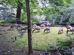
A day of feathered friends and squirrels! Through the Wallasey tunnel, £1.30 these days, and parked in Ashville Road between the lower and upper Park.The first wildlife were squirrels spotted by Chris as we walked around the first lake. The geese, see above, were cropping the banks of the lake and, apart from an initial interest to see if we had bread, were not bothered by our presence in any way. Further on we were greeted by a variety of ducks and their young...
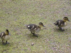
Convinced we did have food. The ducklings left positive bow waves as they dashed across the lake. Chris kept telling them we didn't have anything for them (as if they understood!)Back onto the perimeter road to the gates between Kemp's House (whoever Kemp was/is!) and the Castellated lodge. The next part was surprisingly rural, eventually crossing Wirral Ladies Golf Course (I'll resist any comments) and onwards to Storeton Ridge. The views were surposed to be of the "Wirral Peninsula and the Dee Estuary over to the hills of North Wales". Perhaps in winter this may be the case but at this time of year the hedges/trees etc blocked any view.Down through modern housing we then headed back up the hill to get confused by the written directions (outside St Saviour's Church). The problem was, the writer of the guide gave the wrong name for the road! Very annoying! That sorted we went on our way through Oxton Village, which is a conservation area; disappointing as again the write-up suggested it would be more impressive than it was. Perhaps we are getting too critical, having seen so many nice villages/conservation areas. Don't get me wrong, there are some wonderful buildings along the walk but many are looking 'tired'. Down Christchurch Road past

Christ Church, on our right; in the distance Chris spotted St John's Tower (Liverpool); if you look carefully you will see it on the horizon.The next port of call was the Williamson Art Gallery; not been before and well worth a visit. On permanent display are Victorian oil paintings, English watercolours, Liverpool Porcelain and Della Robbia Pottery. A range of collections: from local history and ship models to fine decorative arts, part of the Merseyside Embroidery Trail and a display of wildlife photography were the highlights
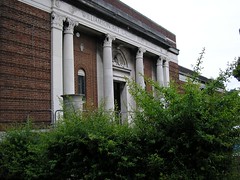
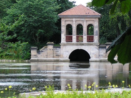
Back into Birkenhead Park, via the gate next to the Italian Lodge, we passed the wildlife pond and went around the lower lake with views of the Swiss bridge...

and the boat house...
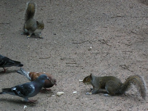
Squirrels and pigeons, which for some reason Chris kept calling penguins, competed for bread...
...and generally kept us amused until we reached the new "Visitors' Pavilion" with their formal gardens...
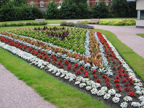
They reminded me of the Abbey Gardens in Bury St Edmunds (My home Town!) After a drink in the pavilion (Chris also had toasted tea-cakes) we headed back to the car and home.The walk made me realise how wealthy the area had been in the past and it was nice to see attempts to revitalise the park. Many of the 'mansions' were now converted into flats and, as I've already said, many of what were fine buildings were looking tired!

Thursday, July 12, 2007

Post2Blog3

Today I’ve looked at this WYSIWYG (what you see is what you get) blog editor; apparently it used to cost about £20 but now is absolutely FREE!

So far it has been easy to use and the keyboard shortcuts for Microsoft(c) Word all appear to work (I haven’t tried them all yet!) There are some handy features...

  • Clicking the Advanced icon provides extra tools including bullets

  • a live spell-checker

  • a toolbar for Microsoft Word and

  • add-ons for Internet Explorer and Firefox.
I’m impressed so far and if you are reading this, my first blog using Post2Blog - a desktop blogging client for Windows. This is an example of quick snippet that inserts link to Post2Blog and text if you type "Post2Blog". To disable this quick snippet just remove it via "Tools" | "Manage Quick Snippets". 3.01 has worked.

PS you can download it, if you wish, from http://bytescout.com

Sunday, July 08, 2007

Crowden and Torside Reservoir Walk: Map and Images

For the map of the walk visit http://quikmaps.com/show/38217
I must say, especially after all the rain we have had, that the engineering skills of the Victorians is most impressive...

1 Weir at lower end of Torside Reservoir

2 Weir at lower end of Woodhead Reservoir

3 Second weir at the lower end of Woodhead Reservoir

The plants were also impressive

1 Orchids on the Trans Pennine Trail...

2 Cones on conifers (where else would you find them?) in woods after crossing the B6105

On the way home we stopped to look at a Well Dressing

1 The complete dressing...

2 A close up

Blogged with Flock

Return to Crowden!

Today we returned to Crowden which was the walk recorded in our first ever Blog last year! On looking again the date said 31 August when in fact it was 31 July!! We had found wild cherry trees and had decided to return this year armed with bags in order to collect more than my tummy could hold. However, as all best laid plans it was not to be. Firstly the relevant section of the path was closed for repair work and secondly the couple of trees that we did find had cherries but not ripe ones! This disappointment was somewhat balanced by the array of purple orchids which J photographed and will hopefully add. (added)

It has been a wet week again but we just about managed to dodge the showers today. We went to the Hare & Hounds on Wednesday for our ‘free meal’ after the last troublesome visit. The food was OK this time but the truculent waitress left a lot to be desired when she informed us that our food had been ready for ages but she didn’t know where we were sitting!

We went to the Everyman on Thursday with Mel to see The Cruel Sea. This was a play built up from interviews with Liverpool sailors from the Merchant Navy who had kept the supply lines open during the Second World War at great risk to themselves. It was good but the actual interviews which formed part of the dialogue were difficult to understand which was a pity. It had been put together by the same man who did Unprotected which was about Liverpool prostitutes and was much better in my opinion!

Saturday, July 07, 2007

And now for something completely different!

Well you may find that there isn't anything worth watching on TV tonight! If so why not go to http://www.mogulus.com/locus and watch my TV channel (RSC Northwest)
It is experimental at the moment but we currently have a 'storyboard' of 5 video clips
  1. Liverpool Meeting May 2007
  2. RSS in Plain English
  3. All about the RSC-Northwest
  4. Wikis in Plain English
  5. Social Networking in Plain English
Currently running on Auto-pilot.
The plan is...
...to produce videos of events and/or training
...to show them...
...as a loop and/or
...live (scarry)
so that managers, administrators, eGuides, practitioners etc., who are unable to attend face-to-face events, will be able to experience martini learning (any time, any place...)
If the scrip works you should be able to see the TV channel below! Enjoy...


Blogged with Flock

Sunday, July 01, 2007

Maghull, Sefton and the Mersey Forest

No travelling today, we decided, especially looking at the weather, to stay close to home. So down to Maghull Station and off along the Canal (Leeds And Liverpool) towards Aintree.

Apparently Maghull is listed in the Domesday Book, its name of Anglo-Saxon origin meaning a corner of land where mayweed grows (Chamomile).

Along Brewers Lane, the back way to Melanies, and up the lane through Wood Hall Farm. built in the late 17th Century. Between the farm and the underpass beneath the railway we saw lots of poppies among the oilseed rape...

Under the railway and over the M58 we eventually arrived at the new crossing on the A59. Instead of our usual route over the bridge, we went under it and onwards for about 500m beside the River Alt. Crossing the bridge into the Mersey Forest, we turned left and headed along the opposite bank of the river towards Sefton Village. We kept our eyes open for the 'Owl Statue' as we walked.

We saw the 'Owl'; the forest is growing quite rapidly and it isn't going to be long before he/she can't be seen from the road or various paths; he/she will only be visible in their clearing among the trees.

Cinnabar Moth Catterpillers were visible in large numbers although very small at this time of the year...

Its is wonderful how these prison clad caterpillers turn into such bright moths

http://www.ukmoths.force9.co.uk/Cinnabar070798.JPG

As we have already mentioned the origin of the name Maghull, Sefton means 'a farmstead where rushes grow'. It predates the Domesday book and has a 14th Century church, St Helen's, a Grade II listed building.

Down the path we used two years ago to collect elderberries for wine, we entered the Mersey Forest again and returned back to the banks of the River Alt. Oyster catchers greeted us, three of them, as did the rain; we had already got wet from the long grass, now it rained. Up to Showrick Bridge, Chris wanted to cross it, we walked away from the river and around to Moor Lane. At the second path off to the left we were expecting to see a 'wooden sculpture of a hare'...

Anything less like a hare I have yet to see; the long tail wound around a 'stem', and the shape of the ears was enough to confirm it was a mouse!

We made our way along side Roughley's Wood and up onto the embankment beside Harrison's Brook. We rejoined the path (past the elderberry bushes) and on reaching the road looked for and found the capped well of St Helens...

Homeward bound now, we re-passed the Punch Bowl (remember working there Ben?) St Helen's Church and re-entered the Mersey Forest again. Making our way across the forest we ended up walking on an enclosed path across the back of Maghull High Playing Fields; out onto Ormonde Drive and around the corner to the Meadows pub.

Passing through the impressive gates into King George Field, we crossed behind the Town Hall, up the steps onto the A59 and then back down onto the Leeds and Liverpool Canal bank.

We made our way back to Maghull Station and home!

By the way, the Boat yard looks very smart now with new windows etc. I know, it wasn't to be!

An easy walk on level ground, no stiles; pity about the odd shower! Quickmap available at http://quikmaps.com/show/37762

technorati tags:, , , , ,

Blogged with Flock

Saturday, June 30, 2007

Sudley House

shows an exterior shot of Sudley House Museum

What do you do on a wet Saturday in 'Flaming June'? Go to Sudley House of course!

Having 'Googled' Liverpool's National Museums, and avoided WILFING, we (well Chris if I'm honest) decided we would visit this 1821 built house. It was originally owned by Nicholas Robinson, a corn merchant, but, in 1883 was purchased by George Holt, a shipowner.

The ground floor is much as it was with original decorations and Holt's picture collection; I must say the collection was quite impressive and well worth a visit jut to see them. Just as a point of interest, this is the last Victorian merchant's house in Britain that still has its paintings!

His daughter lived there until, still single, she died in 1944; she left the house, paintings and grounds to the people of Liverpool. In 2004 the house was awarded £187k for general improvements, from the National Lottery fund and a year later closed for about 12 months for refurbishment.

Ground Floor

As in most of the house the original furniture has been sold off; the walls however are a perfect setting for the Holt collection of pictures. George Holt, on the interactive video in one corner of the Library, informed us that he used this room for a mixture of business and relaxation. There were pictures of him and family members on the wall.

Drawing room...

The family's 'best room'! According to the servant, that greeted us on another video as we entered, George's wife Elizabeth entertained afternoon visitors here. I wonder where she entertained visitors that arrived at other times? The pictures here were paintings by the Pre-Raphaelites.

Dining room...

The replacement table, purchased from a nearby house, was very grand and Holt, on yet another video informed us about sitting in that very room, with their friends, discussing their charitable work. Two Turner paintings hang in this room. Chris wasn't impressed with them!

Morning room...

Another room, another video; Emma Holt this time telling us about her hopes for the future including votes for women, women MPs and who knows what else. She used this room as her office for her charity work. Landscapes are the main type of pictures in this room.

First Floor...

The rooms here, after Emma died, were destroyed to turn the space into public galleries; modern displays on themes from the period when Sudley was a home can be seen here, including...

  • the Childhood room (looking at Victorian childhood through the themes of mealtimes, getting dressed and learning through play; there is a novel idea!)
  • the Small world room (toys that were miniature versions of real things)
  • the Costume room (displays of costumes and fashions)

Special Exhibitions room...

An excellent display of photographs, by Bedford Lemere, showing Merchant Palaces, Liverpool and Wirral mansions. They were taken between 1888 and 1916. Most are the work of Harry Bedford. He used natural light and long exposure times which meant he rarely included figures. WOW! The sharply focused images provide more than just an insight into the private world of Liverpool's elite. I'm not sure if the black and white photographs would have been any more impressive in colour; the riot of clashing patterns and textures are in all the photographs and, visually, I think it would have all been too much.

Tea room...

Yes we did pay a brief visit for Tea and Sudley Slice for Chris and Coffee and Paradise Slice for me.

A grand day out! A pity that it was raining, a walk in the grounds looked inviting. Perhaps another visit is needed?

technorati tags:, , , , ,

Blogged with Flock

Monday, June 25, 2007

Map as Promised

Using Quikmaps I've produced a map of the walk; it can be viewed at http://quikmaps.com/show/37334

One of the things I like about this 'mash-up' is...

  • the map is saved and can be edited / updated etc. at a later date.

technorati tags:, , , , ,

Blogged with Flock

Sunday, June 24, 2007

Upholland- Beacon Park and Dean Wood

Before I tell you about todays walk you may have noticed, on the right, that I have added AnswerTips to our Blog! Basically it means that you can double-click on any word in our blogs and a 'Pop-up' will appear providing concise information about the word. If that isn't enough, the full collection of sources on the topic is just a click away in the 'more' button. If you want to AnswerTips your website or blog, go to http://www.answers.com/main/answertips.jsp to get the HTML code.

Now todays walk...

For a change, we only drove to Beacon Park (Upholland/Skelmersdale) and, as the journey was so long, Chris volunteered to drive. Her 'speed awareness course' has, for most of the time, kicked in with a vengeance. 28ish up to the M58 and 65ish on the motorway. How time passes when travelling at such speeds!

Eventually arriving at Beacon Park Golfclub car park, we set off past a quite impressive dry stone wall...

embedded with 'flora & fauna' plaques...

We made our way up to the 'top car park' where the is a trig-point and apparently lots of kite flying; there were notices everywhere telling them to 'go fly their kites at the top end of the fields (Health & Safety). I wondered if there was a "Federal Law" about kite flying! :-)

Leaving the Park via a style, we headed down an old road and past a farm, which has recently been converted into apartments, emerging onto a road near what was once a Roman Catholic College. We past the main entrance to the former college (fenced off as if building/conversions were imminent) and headed down some fields following a line of telegraph poles.

To say it was wet was an understatement. My legs were getting soaked when Chris let out a yell. Turning quickly to rush to her aid, I found her pointing down into the long grass...

...she had been frightened by a vicious chick who was now playing dead, hoping we would leave a.s.a.p. We did.

Along a lane and enclosed footpath, to the right of Dean House Farm, we briefly entered a golf course (we haven't played here! One for the future perhaps) before heading down into Dean Wood.

Oyster Mushrooms were identified by Chris...

... which, according to her, would cost a fortune in the shops. She wasn't confident enough to take them home for tea!

Erosion along the banks of Dean Wood was apparent; many trees had exposed...

Quite impressive arn't they?

We had had quite alot of rain over the last few days so the noise from the stream was very intrusive but, in a nice way...

One particular place, where we have walked many times, we saw a waterfall...

...where normally we just commented on the liverworts, ferns etc., and told Ben to get out of the small caves (just to the right of the photograph, out of shot).

Two bridges were 'beyond crossing' and as a result we ended up having to climb away from the stream. I'm sure Ben, Mandy and Mel will remember the quagmire created by the equines near the canal end of Dean Wood. Well it is worse than ever. What a shame that Lancashire CC have allowed such a beautiful Wood to become so messed up by a minority of people and their animals. This part of the walk was, as you can emagine, hard work and I managed to slip onto all fours; muddy paws again!

We didn't manage to follow the instructions for our walk, emerging from Dean Woods earlier than we should, but managed to get back on track before the road that leads to the Fox Inn (Mandy: - 18th Birthday meal to remember!)

Turning right, no we didn't stop (too early they were not open) we made our way across an abandoned golf course and onto a road at Dalton. After a short walk along the road we turned left through what was the ruins of a farm and associated buildings; it looks as if someone was going to rebuild it! A very formidable task as there wasn't much left.

Beyond the farm we made our way across fields to join the road just before the turn to the car park. We decided to cross the stile and cross Beacon Park than to follow the road as the instructions suggested.

A lovely walk spoiled only by the churned up paths mentioned earlier; we had one brief shower but as I type this, it is positively precipitating it down outside. (See I've added lots of big words for you to try out AnswerTips!

Where is the map I hear some of you say? Well I've found a new mapping tool and I'll add the map later! Watch this space!

technorati tags:, , , ,

Blogged with Flock

Sunday, June 17, 2007

Panopticon for Pendle - Atom

Pan... what? The weather today wasn't very promising and we eventually decided to go back to Wycoller to do the two other walks, combined as one. The URL for the route we took is: http://www.gmap-pedometer.com/?r=1055379

Chris, as she is wont, went to look at the noticeboard and map only to return with this, new to me, term 'Panopticon'. Apparently the 'spaceship' we had seen on our last walk around Wycoller was a Panopticon; a structure, space or device providing a comprehensive or panoramic view!

More of this later; dressed for the rain that appeared to be due any minute, we set off; away from the car park (and away from Wycoller) and across fields past Slack Farm, across the small tributary of Wycoller Beck and onwards to Souteril Laith. The Farm Building conversion here was underway and after brief inspection we continued to Winewall past a disused quarry. We watched briefly Kestrels, that were apparently nesting on the quarry face.

Down through Winewall, a very attractive East Lancashire village (the incline too steep for Chris to want to live there) past the Cotton Tree Inn; yes I did say past! and over the Colne Water.

We then turned right and followed the river Colne Water to Laneshaw Bridge. The mill pond and weir were two of the attractions on route.

Dog Roses were in most hedgerows, although in a week they were well past their best.

From Laneshaw Bridge we followed, what was now Wycoller Beck, to Wycoller. This East Lancashire village is just as if you have stepped back in time; wonderful! At the back of the ruins of Wycoller hall we sat briefly for water (we had plenty) and banana.

Climbing the steps at the back of the hall we headed up, what I found out later, an Old Coach Road. the Panopticon could be seen above us...

It was apparently the winner in the international Panopticon competition organised in association with the Royal Institute of British Architects in summer 2003 to find original ideas for East Lancashire's new landmarks.

Our instructions should have taken us along a path below but I decided I need a closer look and Chris was just a keen.

You must admit it was worth going to see! The view as we entered...

was impressive and having admired the views, turning back towards the door was just as impressive.

If you click on the images you will find greater detail and additional information, on flickr.

From the Panoptican we went higher up and past Foster's Leap; a impressive group of boulders, overlooking a very green Wycoller valley. It was then down past the side of the old farmhouse and diagonally across fields towards Parson Lane Farmhouse. Crossing Wycoller Beck again we past along the track through Smithy Clough, returning to Wycoller along Smithy Lane. On the way we past a series of willow sculptures, near the Aisled Barn. (Another project like the Panopticans, called Land).

Refreshments were consumed at the Craft shop in the centre of the village before we returned to the car park and home. It was father's day so it was nice to talk to Mandy in Peterborough, Ben in San Francisco and to have Melanie round for tea later that day. All in all, an excellent day was had by all and the rain kept away!

technorati tags:, , , , ,

Blogged with Flock

Sunday, June 10, 2007

Warpers Trail

The URL for the Warpers Trail is: http://www.gmap-pedometer.com/?r=1034113 This includes the detour which seems to happen more often than not these days; I always get a feeling we have gone wrong so thank goodness it is never far out of our way. Who ever wrote the instructions can't count!

We started the fourth and final part of the Witton Weavers Way at the car park next to Turton & Entwistle reservoir.

Heading back towards the Green Arms Road (B6391) along the right-hand of two gullies (Chris it is "a deep ditch or channel cut in the earth by running water after a prolonged downpour") past a tiny reservoir and up the hillside.

Crossing the road down to the car park we continued up the path, turning right at Green Arms Road and 1st left along a track past Clough House.

Taking a left we crossed the Blackburn to Bolton Railway line, past an old waterwheel and Turton Tower on our left. For those of you who follow our walks you may remember the bridge...

and the tower...

At the Chapeltown Road we turned left and right past the wartime pillbox; used to protect the largest reservoirs and to keep watch over Horrobin Mill, used for wartime storage.

It was then down through the woods and over the bridge at the end of Jumbles Reservoir

Turning left we followed the reservoir as it narrowed into Bradshaw Brook. We emerged from the woods at Turton Bottoms and crossed a bridge with cobbles on it! I'm not sure what Chris was expecting when I said we would cross the cobbled bridge but it wasn't what I have described!

From 1800 there was much industrial development here including a spinning mill, bleachworks, colliery and stone mill. Turning right, further up the road, we crossed Packhorse bridge with its ford and emerged on another cobbled road.

Turning right down Birches Road we past Printers Cottages on our right and turned left.

We then turned right through new houses and up steps out of Quarlton Vale.

The village we had passed through was one of the most attractive I've seen and the views as we reached the top were impressive as well...


Across several fields, past a waterfall...

we followed the stream. After climbing the hill we crossed a track and walked through the Barlow Institute playground and the bowling green onto the main Bolton Road.

Turning left we headed downhill to the Black Bull Public house. Taking the footpath at the side of the pub, we headed towards Wayoh Reservoir. Climbing the path by the rails we kept near the reservoir to eventually reach Hob Lane.

You may be pleased to know we had taken plenty of water with us today! It was needed with the sun burning down.

Apparently at the second bridge we were to take a narrow path that leaves the main track off to the right. We did, our first mistake! Apparently the writer couldn't count! It was the third bridge; by the time I was positive we had gone wrong our 8.5 mile walk was now going to be 9.75 miles; damn!

We eventually reached Edge Lane, turned right and crossed the railway. The "walker's popular haunt, the Strawbury Duck" was a welcome feeding station; far too much for Chris but I managed and the two pints were very welcome!

We continued along Edge Lane, taking the left of the three forks ending up above Turton & Entwistle reservoir. Directions were not that clear again but without too much trouble we found our way back to the banks of the reservoir.

We continued until we approached the end of the reservoir and took the path on our right back to the car park.

Probably the best walk we have done for a long time. The day was too hot for my liking but the walk itself was varied and interesting along its whole length.

So endeth the Witton Weavers Way. What is next?


technorati tags:, , , , , ,

Blogged with Flock

Saturday, June 09, 2007

Gmaps Pedometer for Tacklers Trail

The URL for the Tacklers Trail is: http://www.gmap-pedometer.com/?r=1030995

technorati tags:, ,

Better Late than Never!

The Tacklers Trail

I had half expected Chris to write up this walk as I've been down in Hadleigh. Went down Thursday afternoon and arrived back about an hour ago. eXe Workshop in Whitham, Essex.

Any how, our 9.5 mile walk (I'll check the distance when I do the map) had more tha a couple of "short steep slopes" but the guide was spot on about the rough moorland path (Darwen Moor)

We started in Sunnyhurst Wood (you may remember that we have been here earlier in the year to look at pictures by Chrissie's father-in-law; Chrissie from work!) and following Sunnyhurst Brook we emerged by an iron gate at the corner of Earnsdale Reservoir.

Skirting the reservoir we arrived at Tockholes Road, (built in 1840s to link Tockholes with Darwen) Chris then said "That's a pleasant view!"

She gets worse! But just in case we were not aware of the vision before us, it was labelled.

We the passed through woodland towards Roddlesworth Upper Reservoir and crossed "Rocky Brook" the local name of the River Roddlesworth. Continuing alongside the brook we crossed Halliwell Fold Bridge and walked with the brook now on our right.

It was damp enough for fungi to flourish.

We had been through these woods and along this very path when we did the Lancashire Trail; in the opposite direction however.

After some distance we arrived at the ruins of Hollinshead Hall, the manor house of the Tockholes.

The wellhouse...

...as you can see above, still stands. Five springs of water meet here and they have legendary healing properties for eyes.

Continuing, after a short refreshment break, we made our way up onto Darwen Moor pausing to rest again, after the climb, on a bench at the top; bannana time! the walk accross the moor was warm to say the least; we were dressed for the cool, possible rain and here it was hot and sticky! We hadn't enough water with us! A lesson we need to learn from for future walks.

Curlews, green plovers etc were annoyed at our presence near their nests and one ewe tried frantically to get her very young lamb up a very steep bank...

The poor think could hardly walk let along climb.

The big question for the whole walk was "Where are the ruins of Top o' th' Brow farm? They were ment to be on the right but after much deliberation (and not for the first time on this walk) we eventually found our intended route (only about 2 miles added!)

The heat by now was having an unpleasant effect on me and that together with the poor footing, as we headed for a modern white house, known locally as Lord's Hall, made this part of the walk less enjoyable.

The walk from Lord's Hall drive to Darwen Tower...

(picture taken on an earlier walk) was a struggle; dry mouth and a tongue that seemed to be getting larger. However it wasn't that long before we were heading down towards Sunnyhurst Pub and a very welcome beverage or two!

The walk is one that I would do again but either with more water or in cooler weather. Tomorrow it is the Warpers Trail apparently 8.5 miles and the last paart of the 32 mile long trail; more water and hopefully a little cooler.

technorati tags:, , , , , , , , , , ,

Blogged with Flock